
St Ives is full of quirky and interesting places and oddities that it is fun to find. I've listed some of them - this is by no means a full list. If you have any that you love and would like me to add then do message me!
1. Smeaton's Pier
LOCATION MAP: Smeaton's Pier, St Ives
Smeaton’s Pier is an iconic symbol of St Ives. It must have been painted and photographed more than almost any other pier in the UK. It is far prettier and more interesting than its name suggests!
It was named after the pier engineer in charge who was called John Smeaton. It was built between 1767 and 1770 and interestingly has a reservoir at its base. This fills up at high tide, helping to reduce the wave action into the harbour.
There are 2 lighthouses on there, the older smaller one is where the pier used to end. It was extended in the 1890s and the larger, white lighthouse was built.
Read more about Smeaton's Pier >>
2. Barnoon Cemetery
LOCATION MAP: Barnoon Cemetery, St Ives
Why include a cemetery? Well this is a cemetery with history, beautiful wildlife and THE most stunning view! It also has some fascinating grave stones, some very beautiful and others very poignant, being part of St Ives historical events. Look out as well for the grave of Alfred Wallis, covered in tiles made by his friend the potter Bernard Leach.
Read more about Barnoon Cemetery >>
3. Knill's Monument
LOCATION MAP: Worvas, Saint Ives TR26 2AY
Knill’s Monument is the spire on top of the hill overlooking St Ives. You have probably seen it and wondered what on earth it is about!
It was built by John Knill in 1767 as a memorial to himself! It was originally built as his mausoleum, but he ended up being buried in London.
Knill left money in his will to the town for them to perform a ceremony in his honour once every 5 years. It is still performed to this day - the next one is in 2026 on July 25th.
Read more about Knill's Monument >>
4. St Eia Church
LOCATION MAP: 15 St Andrew's St, Saint Ives TR26 1AH
The St Eia Church is the big parish church in town near the RNLI station. It was concecrated in 1434. It is dedicated to the Celtic saint St. Ia, and also to St. Andrew, patron saint of Fishermen and St Peter, the Rock. The church is built of Cornish granite from Zennor and the tower is one of the tallest of the cornish churches, standing over eighty feet high, like a shepherd watching over its flock on land and sea.
Read more about St Eia Church >>
5. Wreck Of The Alba
LOCATION MAP: Porthmeor Beach, St Ives
The coal ship the SS Alba was wrecked on the Three Brothers Rocks on 31st January 1938. The lifeboat was launched but capsized in huge waves, leading to the loss of 5 of the Alba crew. The boat broke up and all that now remains of it are the boilers which can be seen at low tide on Porthmeor Beach.
6. St Leonard's Chapel
LOCATION MAP: Smeatons Pier, Saint Ives TR26 1LP
St Leonard’s Chapel is a tiny little chapel situated at the entrance to Smeaton’s Pier. It has been there since medieval times. It is where the fishermen used to pray before setting out to sea. Apparently, in “the olden days” a proportion of the fishermans’ catch had to be paid to the chapel friar on their safe return.
7. St Nicholas' Chapel
LOCATION MAP: The Island, Saint Ives TR26 1SZ
St Nicholas Chapel sits on top of The Island in St Ives overlooking the bay, beaches and out to the rolling Altantic.It is in a stunning spot and well worth a hike up the hill to look. It is a tiny little chapel that can fit about 10 people inside.
Read more about St Nicholas' Chapel >>
8. The Gun Battery
LOCATION MAP: Island Rd, St Ives, Saint Ives TR26 1NT
Our little island in St Ives was considered to be of strategic importance in the 1850s! A gun battery was built in 1859 to help protect the area from French invasion. It consisted of a 3 gun emplacements and an ammunitions cellar. What is now the Surfhouse St Ives used to be the barracks that housed the gunners and their families.
9. The Oldest House
LOCATION MAP: The Oldest House, 5 Fish St, Saint Ives TR26 1LT
If you are on The Wharf by The Sloop Inn, turn up Fish Street and look to your right. Number 5 Fish Street is quite an unassuming building, made from granite. This is reputed to be the oldest house in St Ives and is believed to have being built in the 1600s. It's basement is cut into the bedrock which must be fascinating to see!
Read more about the oldest house >>
10. The Oldest Pub
LOCATION MAP: The Wharf St Ives, Saint Ives TR26 1LP
The Sloop Inn is an iconic landmark of St Ives. Who hasn't sat outside in the sunshine drinking a pint of Doom Bar, watching the crowds go by?
The Sloop Inn is said to be the oldest pub in St Ives. It is dated to circa 1312 which makes it pretty old!
Read more about the oldest pub >>
11. Cintra Anchor
LOCATION MAP: Smeatons Pier, Saint Ives TR26 1LP
The Cintra Anchor comes from one of four ships wrecked in St Ives Bay in the Great Gale of 18th November 1893.
Read more about the Cintra Anchor >>
12. The Huers Hut
LOCATION MAP: Hain Walk, Carbis Bay
A “huer” was a person who stood on a prominent lookout on the cliffs, looking for the telltale shine of a pilchard shoal. They would cry out loud enough for the boats to hear in the bay, and help direct the fishermen to the fish.
The Huer's Hut is where the lookout would wait - it obviously has one of the best views of the bay in town!
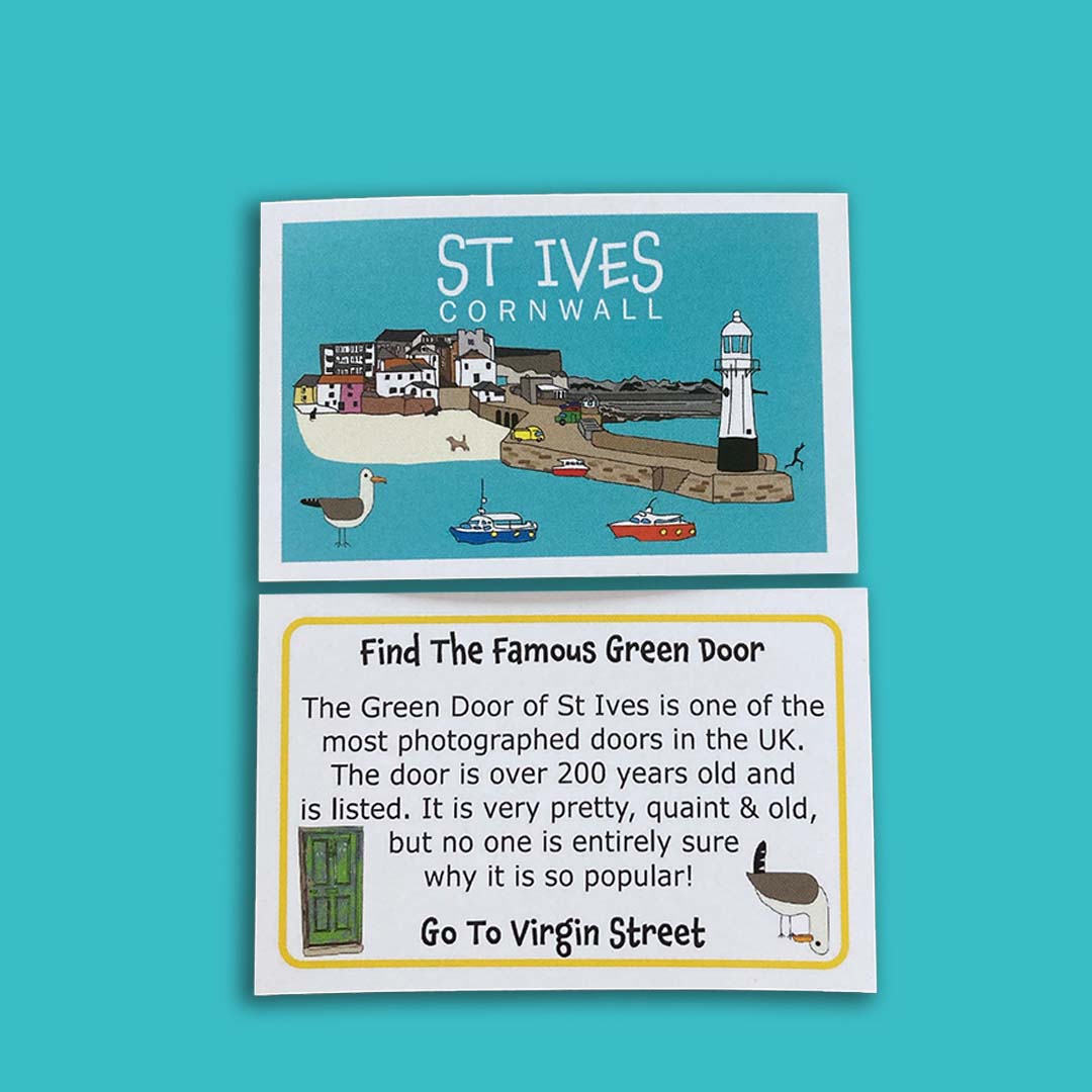
13. The Green Door
LOCATION MAP: 1 Virgin St, Saint Ives TR26 1HP
The Green Door in St Ives has become bizarrely internet famous. It has become something of a thing to have your photo taken in front of it and post it online!
Read more about the Green Door >>
14. Alfred Wallis's House
LOCATION MAP: Back Rd W, Saint Ives TR26 1NF
Discover where the artist Alfred Wallis used to live. Look out for the plaque on the side of the house.
15. Town Sculptures
Across town, there are several Barbara Hepworth Sculptures to be seen.
Dual Form - outside The Guildhall on Street-an-Pol
Epidaurous - overlooking the bay in the Malakoff Gardens
Madonna and Child - a moving tribute to Barbara’s eldest son Paul, who was killed in a plane crash in Thailand in 1953.
There is also a memorial to Dame Barbara herself, made by her pupil and assistant John Milne. It is called Megalith and sits in Trewyn Gardens.
16. Well Of St Eia
LOCATION MAP: Porthmeor Hill, St Ives
Visit the holy well of St Eia, which, until 1843 was the main water supply for the Downalong area of St Ives. It is now used during the St Ives Feast Day celebrations.
Read about the St Ives Feast Day celebrations here >>
17. War Memorial
LOCATION MAP: St Andrew's St, Saint Ives TR26 1RY
The St Ives War Memorial is in the shape of a Celtic Cross. It sits in the memorial gardens in St Ives, and shows 109 names from World War I and 93 from World War II.
18. NCI Coastguard
LOCATION MAP: Island Rd, Saint Ives TR26 1NT
The NCI Station at St Ives sits high on the extremity of the Island promontory. Volunteers monitor weather and sea conditions and provide information for mariners, fishermen, walkers and other users of the sea and coast.
You can go into the station for a look around (providing they are not too busy) and they also have a little second hand bookshop.
Follow them on Facebook as they provide loads of interesting information on there, from the weather, tides and dolphins and whale sightings!
NCI Coastguard Facebook page >>
19. Fishermens Lodges
Have you ever wondered what those fairly unprepossessing wooden building are on the harbour? The are the Fishermen’s Lodges. There are two on Wharf Road - Shore Shelter and Rose Lodge, and Shamrock Lodge is the one by The Sloop. There were originally 5, but 2 fell into complete disrepair and no longer exist.
They were used by fishermen waiting for the tide and are now used for socialising and keeping traditions alive. Money is being raised to help bring them back to life - lots of repairs are needed!
Interestingly, swearing in the lodges is strictly forbidden. But spitting and smoking is fine!
Read more about the lodges here >>
20. Kitty's Corner
LOCATION MAP: Harbour Beach, St Ives
Kitty’s Corner is an iconic spot in St Ives. It is the little corner on the Harbour Beach by the sweet little cottages and the dream Quay House. It is called Kitty’s Corner after the lady who used to live there with her cats. She could often be seen feeding them and the seagulls on the beach. Because of the way that corner of the beach faces, it is often warm, sheltered and sunny, even in Winter.
Read more about Kitty's Corner here >>
21. The Invisible Man
LOCATION MAP: Wheal Dream, St Ives, Saint Ives TR26 1PR
Have you seen the invisible man? He lives overlooking Bamaluz Beach on Wheal Dream - a more St Ives-y sentence I could not write! In good weather he is there, ready to have his photo taken (£1 donation please). When the wind blows too strong he becomes well…invisible!
22. The Arches
LOCATION MAP: Harbour Beach, St Ives
Ever wondered why there are 3 arches under Smeaton's Pier? They were built to help circulate the seawater and prevent the build up of sand in the harbour.
They also make a great place to place in for my kids!
23. The Stone Balancers
LOCATION MAP: Lambeth Beach, St Ives
If you wander past the RNLI building along Lambeth Walk, you will get to Lambeth Beach. Often you will find people creating the most amazing stone balancing sculptures. I've no idea how they do it - it isn't glue as they always come crashing down with the next high tide.
Read more about the stone balancers of St Ives here >>
24. Hick's Arch
LOCATION MAP: Hicks Ct, Saint Ives TR26 1HS
Walk down The Digey and peer down Hick's Court. You will see a granite arch leading into the courtyard of houses. There is a plaque that reads
"This arch marks the entry to Hick's Court where stood the house of George Hicks, Portreeve, 1611 and 1624."
It is grade II listed and once marked the entranceway to an old Manor House belonging to the Hicks family.
25. The Little House
LOCATION MAP: The Wharf, Saint Ives TR26 1PB
How thin is this house? I believe it was originally built as an undertakers (I can't remember where I heard this though - if you know better please let me know!). It apparently has the steepest stairs!
26. The Dolls House
LOCATION MAP: Back Rd W, Saint Ives TR26 1NG
This is another amazing looking house to look out for. It sits on Back Road W and is covered in foliage.
27. Norway Square
LOCATION MAP: Saint Ives TR26 1NA
The name Norway is often heard in St Ives. It has nothing to do with the country, Norway, more it is a corruption of the phrase "North Way". Norway Square is a really delightful little garden tucked away down Back Road. The buildings around it are listed and have such character.
28. Daphne Du Maurier
LOCATION MAP: 1 Bethesda Pl, Saint Ives TR26 1PA
Tucked away in the heart of Downalong is Cornerways Guest house and this is where Daphne Du Maurier used to stay when she visited St Ives. Look out for the plaque on the front of the house.
29. The Malakoff View
LOCATION MAP: The Terrace, Saint Ives TR26 2BP
One of my favourite places to go in St Ives is the Malakoff gardens to sit and look at the amazing view.
30. The Telephone Box
LOCATION MAP: The Terrace, Saint Ives TR26 2B
If you walk up Tregenna Hill and look to your right, you will see a telephone box with St Ives on it. This often gets decorated for festivals and celebrations, and is lovely to see.
31. The Leach Pottery Mural
LOCATION MAP: Smeaton's Pier,Saint Ives TR26 1PS
If you are on Smeaton's Pier, turn down the slipway and under the covered seating area. On the wall there you will find the most amazing mural.
32. The Inscribed Benches
LOCATION MAP: Smeaton's Pier,Saint Ives TR26 1PS
Again, in the same place as the Leach Pottery Mural, you will find some wonderful inscriptions on the benches there.
33. Quay House
LOCATION MAP: Quay St, Saint Ives TR26 1PE
I think nearly everyone who has been to St Ives has had a little fantasy about living in Quay House. It is the big house in the corner of the harbour by Smeaton's Pier with palm trees and a garden overlooking the beach. It sits on what is known as Carnsew Rock and often looks like it glows in the St Ives light.
Read more about Quay House here >>
34. Market House
LOCATION MAP: Market Pl, Saint Ives TR26 1RZ
The roundish sort of building that sits in the middle of Market Place in St Ives is known as Market House. It was built in 1832 but is the site of the much older Guildhall, which dates back to 1490s. The current building was originally a market on the ground floor, and the Guildhall was upstairs. The mayor and town council would meet here and there was also a town court and jail.
The new Guildhall was built in 1939 and all town council duties were moved there, leaving Market House to become shops and a pool and billiards club.
35. Doble's Wall
LOCATION MAP: The Wharf, Saint Ives TR26 1PG
"Doble's Wall, Doble's Wall, there's no place in all the world like Doble's Wall"
John Barber was a Cornish Bard and poet who had a deep love for Cornwall which he expressed in verse and music. He wrote the song "Doble's Wall" after the very same wall in St Ives.
Doble's Wall is the wall in front of Mor Beach Cafe on the Wharf
Read more about Doble's Wall here >>
36. Murals
LOCATION MAP:
On the sides of the buildings by the launderette on The Stennack in St Ives are two most amazing murals.
Read more about the murals in St Ives >>
37. Virginia Woolf Talland House
LOCATION MAP: Albert Road, St Ives, Saint Ives TR26 2EH
Talland House in St Ives is where Leslie and Julia Stephen brought their family for three months of every year between in the 1880s and 1890s. Virginia Stephen (who later married and became Virginia Woolf) found the inspiration for her novel "To The Lighthouse". The view from the house looks over St Ives Bay and to Godrevy Lighthouse.
38. Middle Lighthouse
LOCATION MAP: Smeaton's Pier, St Ives
Why are there 2 lighthouses on Smeaton's Pier in St Ives? The smaller, older one marked the end of the original pier, built around 1770. The pier at that time was only 120ft in length. The pier was was lengthened by another 300ft in the 1890s which is when the current lighthouse was built.
Read more about Smeaton's Pier here >>
39. Wood Pier
LOCATION MAP: Wood Pier, St Ives
In 1864 there were grand plans to expand the harbour. The fishing fleet at this time was huge and there was a need for more room. New Pier was built, mainly made from wood (it is sometimes called Wood Pier). The planners must have underestimated the power of the sea in St Ives Bay as it only lasted for 20 years. All that is left now are the rows of supporting timber stumps which can be seen at low tide.
Read more about Smeaton's Pier here >>
40. Love St Ives (on the road)
LOCATION MAP: Digey Flats, St Ives
If you look carefully on the road where Back Road W, The Digey and Porthmeor meet, you can see the word "LOVE". It is sometimes clearer than others as the council likes to put it back to "SLOW"!
41. The River Stennack
It was only when I read about the terrible flood on 11th November 1894 that I realised The Stennack (the main road) was named after the river Stennack. The river flows down The Stennack by the side of it and under it from Consols Pond. It empties into the sea on Lambeth Beach, in front of St Ives Parish church.
Read this really interesting account of the St Ives flood >>
42. Consols Pond
LOCATION MAP: Consols, St Ives TR26 3AD
Consols Pond is found at the very top of The Stennack, behind the roundhouse at the junction. At Eastertime there is a town tradition of sailing small boats on it, which has recently being revived.
43. Mr Peggotty's Nightclub
Okay, this isn't actually there anymore, but I wanted to include it as so many people still talk about it. It was a nightclub that ran from the 60s until around 2008 (I think?) when it was closed down and turned, yes you know it, into holiday lets. It was located near the Island and apparently was a legendary place to have a night out in.
If you have a meal in The Mermaid on Fish Street, there are old photos on the walls there showing what it was like.
44. The Padlocks
LOCATION MAP: The Island Steps, St Ives
If you walk round The Island and up the steep stairs that take you to The Surfhouse and Coastguard, you will find lots of padlocks attached to the railings there. Lots with sweet love messages on. Some love them, some hate them - I think they are lovely as they symbolise hope and love!
45. The Benches
Dotted around the headlands, the island and lots of lovely view points are benches with some beautiful messages on to loved ones who loved St Ives.
Sitting on them and enjoying the view always makes me smile.
46. Custom House Passage
LOCATION MAP: Wharf Rd, Saint Ives TR26 1LF
Walking though Custom House Passage on a wild stormy night is like taking a step back in time. It is an amazing alleyway, full of cobbles and charm.
Custom House Passage is the little narrow alley by the side of Tretho Lounge (formerly Pizza Express, formerly Woolworths).
47. Court Cocking
LOCATION MAP: Court Cocking, St Ives
Court Cocking is another of my favourite little alleys in St Ives. It is tucked in by Court Arcade (look for the bright Rubydoobies sign) and the swanky Beach Cafe Bar on Wharf Road.
48. Man's Head
LOCATION MAP: Mans Head, Porthmeor, Beach, Saint Ives TR26 1JY
Man’s Head is the knobbly shaped rock that sits on the far West of Porthmeor Beach. From certain angles it looks like an old man. It is a lovely place to walk and our children love to climb the rocks there. We love the view of Porthmeor Beach from here and you get to watch the waves from side on.
Read more about Man's Head here >>
49. Train Sculpture
LOCATION MAP: The Train Station, St Ives
Have you seen the really unusual bright blue sculpture at the train station in St Ives?
50. The Festival Of Britain Plaques
There are 6 Festival Of Britain plaques in St Ives. They were made in 1951 at the Leach Pottery as part of the celebrations.
- 5 Fish Street - the oldest house in St Ives
- The Baulking House (Huer's Hut) on Hain Walk
- Hicks Court, just off The Digey
- St Leonard's Chapel on Smeaton's Pier
- The Venton Ia Well at the bottom of Porthmeor Hill
- On The Wesley Chapel behind the Kidz R Us Theatre.